Stay Updated
Please see the News and Notices Page for all City updates.

The City is committed to working with you to understand and utilise your views, concerns, and aspirations, to guide sustainable outcomes in our decision-making processes to strengthen community cohesion, city amenity and the quality of life for the local community.
Our online community engagement hub, Your Voice Nedlands provides you and the community with the opportunity to offer genuine input into a broad range of projects, activities and decisions of Council. The hub also gives us an avenue to communicate decisions and activities.
This page is regularly updated with news such as infrastructure, closures and events.
Please see the News and Notices Page for all City updates.
-
Allen Park Playground - replacement of fencing
Share Allen Park Playground - replacement of fencing on Facebook Share Allen Park Playground - replacement of fencing on Twitter Share Allen Park Playground - replacement of fencing on Linkedin Email Allen Park Playground - replacement of fencing linkIn mid-March 2021, the City plans to replace the existing dilapidated Allen Park playground fence and gates, with a new 1.2m high black PVC coated chain wire fence. The existing alignment of the fence will remain the same. Presently we have confirmation that this work will commence and be completed on the 19 March 2021.
This work will be undertaken during daylight hours and there may be some inconvenience for users of the playground during this time. However, the City will ensure any inconvenience is limited while this work is being undertaken.
If you have any queries in relation to this work, please contact our Administration Centre on 9273 3500 who can direct your queries to the Project Manager.
Please see the News and Notices Page for all City updates.
-
Claremont Train Station - Temporary bus layover on Railway Road
Share Claremont Train Station - Temporary bus layover on Railway Road on Facebook Share Claremont Train Station - Temporary bus layover on Railway Road on Twitter Share Claremont Train Station - Temporary bus layover on Railway Road on Linkedin Email Claremont Train Station - Temporary bus layover on Railway Road linkFrom 8pm Monday 8 February to 5am Wednesday 10 February 2020, Public Transport Authority (PTA) have plans to create a temporary bus layover area on Railway Road while works are being carried out at the Claremont Station as part of the Forrestfield Airport Link Services.
A number of other significant project works will take place during the closure between Showgrounds and Swanbourne stations. Work will take place 24 hours a day and a variety of machinery will be used.
For full details of the work, visit the Metronet project page.
Please see the News and Notices Page for all City updates.
-
Nandina Ave: Camelia Ave to Zamia St - Footpath Upgrades
Share Nandina Ave: Camelia Ave to Zamia St - Footpath Upgrades on Facebook Share Nandina Ave: Camelia Ave to Zamia St - Footpath Upgrades on Twitter Share Nandina Ave: Camelia Ave to Zamia St - Footpath Upgrades on Linkedin Email Nandina Ave: Camelia Ave to Zamia St - Footpath Upgrades linkAxiis Contracting will be carrying out the above-mentioned works on behalf of the City of Nedlands.
Footpath upgrade works along Nandina Avenue, Mt Claremont will commence on Monday 15 March 2021 and should be completed within a two-week timeframe, dependent on weather and resources.
The works will include:- Demolition of the existing slab footpath;
- Service adjustments;
- Installation of a new concrete footpath; and
- Driveway accommodation works.
Works will be undertaken during weekdays, between the hours of 7:00am – 5:00pm. View the site location here.
Please note that some preparatory works will need to be undertaken outside of these dates and may include survey and paint markings.
Lane and footpath closures will be in place with detours around the work site. Local traffic will continue to have limited access whilst closures are in place, and on-site traffic controllers will be happy to assist. The operations team on site will endeavour to offer access to your property at all times, however there may be short periods when materials are required to cure, and on these occasions the City will ensure contact has been made and suitable alternative arrangements have been discussed.
Should you have any further enquiries, please contact the Site Supervisor Jarrod Daniel on 0429 066 5023 or alternatively the City’s Representative, Jason Spyker on (08) 9273 3500.
Please see the News and Notices Page for all City updates.
-
Changes to Bruce Trust Land & Amendments to Scheme
Share Changes to Bruce Trust Land & Amendments to Scheme on Facebook Share Changes to Bruce Trust Land & Amendments to Scheme on Twitter Share Changes to Bruce Trust Land & Amendments to Scheme on Linkedin Email Changes to Bruce Trust Land & Amendments to Scheme linkIn response to public statutory consultation in April 2018 and the Ordinary Council meeting held 24 September 2019, Council resolved for the CEO to put forward a Scheme Proposal to the Office of the Attorney General to vary the Bruce Trust Indenture.
The Scheme for variation of Trust under the Charitable Trusts Act 1962 (WA) was approved by the Hon Attorney General and the Scheme published in Government Gazette number 70 on 8 May 2020 at page 1168.
Please see document library for your reference.The Scheme Variation corrects an anomaly between the Trust land and the existing road along The Esplanade by recognising the road, allowing vehicles to park on the edge of the road and allows for the application of the City of Nedlands Parking and Parking Facilities Local Law 2013 on the road that is situated on part of the Bruce Trust Land. The Scheme Variation does not allow the road to be widened.
Please see the News and Notices Page for all City updates.
-
Lissadell Street - Road Surface Upgrades and Associated Works
Share Lissadell Street - Road Surface Upgrades and Associated Works on Facebook Share Lissadell Street - Road Surface Upgrades and Associated Works on Twitter Share Lissadell Street - Road Surface Upgrades and Associated Works on Linkedin Email Lissadell Street - Road Surface Upgrades and Associated Works linkThe City is undertaking road surface upgrades and associated works on Lissadell Street between Kirwan Steret & Alderbury Street, Floreat.
Roads 2000 will carry out the works, commencing Monday 30 November 2020 between the hours of 7:00am – 5:00pm.
The works should be completed within a three-week timeframe, dependent on weather/resources and will include:
- Kerb removal & earthworks
- Road profiling
- New asphalt base course
- New kerb and crossover installation
- Backfilling works
- New asphalt wearing course
Please note that some preparatory works will need to be undertaken outside of these dates and may include survey and paint markings.
Road closures will be in place with detours around the work site. Local traffic will continue to have limited access whilst closures are in place, and on-site traffic controllers will be happy to assist. View the site location via the Document Library.
Should you have any further enquiries, please contact the Project Coordinator, Nyein Chan Soe on 0437 932 746 or alternatively the City's Representative, Myles Bovell on (08) 9273 3500.
Please see the News and Notices Page for all City updates.
-
Karella Street - Road Surface upgrades and associated works
Share Karella Street - Road Surface upgrades and associated works on Facebook Share Karella Street - Road Surface upgrades and associated works on Twitter Share Karella Street - Road Surface upgrades and associated works on Linkedin Email Karella Street - Road Surface upgrades and associated works linkThe City is undertaking road surface upgrades and associated works on Karella Street between Williams Road & Hampden Road, Nedlands.
Roads 2000 will carry out the works, commencing Monday 23 November 2020 between the hours of 7:00am – 5:00pm.
The works should be completed within a four-week timeframe, dependent on weather/resources and will include:
- Kerb removal & earthworks
- Road profiling
- New asphalt base course
- New kerb and crossover installation
- Backfilling works
- New asphalt wearing course
Please note that some preparatory works will need to be undertaken outside of these dates and may include survey and paint markings.
Road closures will be in place with detours around the work site. Local traffic will continue to have limited access whilst closures are in place, and on-site traffic controllers will be happy to assist. View the site location via the Document Library.
Should you have any further enquiries, please contact the Project Coordinator, Nyein Chan Soe on 0437 932 746 or alternatively the City's Representative, Myles Bovell on (08) 9273 3500.
Please see the News and Notices Page for all City updates.
-
Cnr Stirling Hwy and Smyth Road - Road repairs
Share Cnr Stirling Hwy and Smyth Road - Road repairs on Facebook Share Cnr Stirling Hwy and Smyth Road - Road repairs on Twitter Share Cnr Stirling Hwy and Smyth Road - Road repairs on Linkedin Email Cnr Stirling Hwy and Smyth Road - Road repairs linkNotice on behalf of Water Corporation
The bitumen road will be repaired on the corner of Stirling Highway and Smyth Road following previous maintenance and faults that have occurred.
Works will take place between 7pm to 5am 19 & 20 November 2020.
During this time, you may experience noise, additional work vehicles, mobile plant, flashing lights and traffic management. Every effort will be made to keep disruptions to a minimum.
If you have any other questions about the work, please call our 24-hour faults line, 13 13 75.
Please see the News and Notices Page for all City updates.
-
Western Power Work - Adderley Street
Share Western Power Work - Adderley Street on Facebook Share Western Power Work - Adderley Street on Twitter Share Western Power Work - Adderley Street on Linkedin Email Western Power Work - Adderley Street linkNotice on behalf of Western Power.
Western Power will be carrying out work in Mt Claremont. To ensure the safety of crew and the community, they will need to turn off power while completing this work.
Properties affected: Adderley St Mount Claremont 6010
Start time: Thursday, 12 November 2020 at 08:30 PM
End time: Friday, 13 November 2020 at 05:30 AMWestern Power always aim to minimise any disruption, however sometimes it can take up to two hours to switch the power off safely. Unforeseen issues can also impact when the power is restored.
Should you have any queries, please contact Western Power on 13 10 87.
Please see the News and Notices Page for all City updates.
-
Annual Bushland Spraying Program 2020
Share Annual Bushland Spraying Program 2020 on Facebook Share Annual Bushland Spraying Program 2020 on Twitter Share Annual Bushland Spraying Program 2020 on Linkedin Email Annual Bushland Spraying Program 2020 linkThe annual spraying program is being undertaken by Contractors from July through to October 2020 to control environmental weeds in the following bushland areas:
- Shenton Bushland
- Allen Park
- Hollywood Reserve
- Birdwood Parade Bushland
- Point Resolution Bushland
- Mt Claremont Oval Bushland
- Mt Claremont Community Centre
- Swanbourne Estate
The City will be focusing on the control of bulbous weeds, and annual and perennial grass weeds using the herbicides listed below:- Metsulfuron-methyl: used to control bulbous weeds
- 2 2-DPA (Dalapon): used to control bulbous weeds
- Glyphosate: used in conjunction with metsulfuron-methyl to control bulbous weeds
- Fusilade: used to control annual and perennial grass weeds.
Signage will be displayed whilst these works are occurring.
The City undertakes environmental weed control to improve biodiversity values and to reduce the negative impacts environmental weeds cause to the ecosystems they invade, for example they compete with native plants, thereby reducing the species and diversity for both flora and fauna.
Environmental weeds cause erosion, alter water availability, change soil nutrients, increase the likelihood of bush fires and change vegetation communities within bushland areas.
For further information, please contact Vicki Shannon, the City's Environmental Conservation Coordinator on (08) 9273 3500, or email vshannon@nedlands.wa.gov.au
Please see the News and Notices Page for all City updates.
-
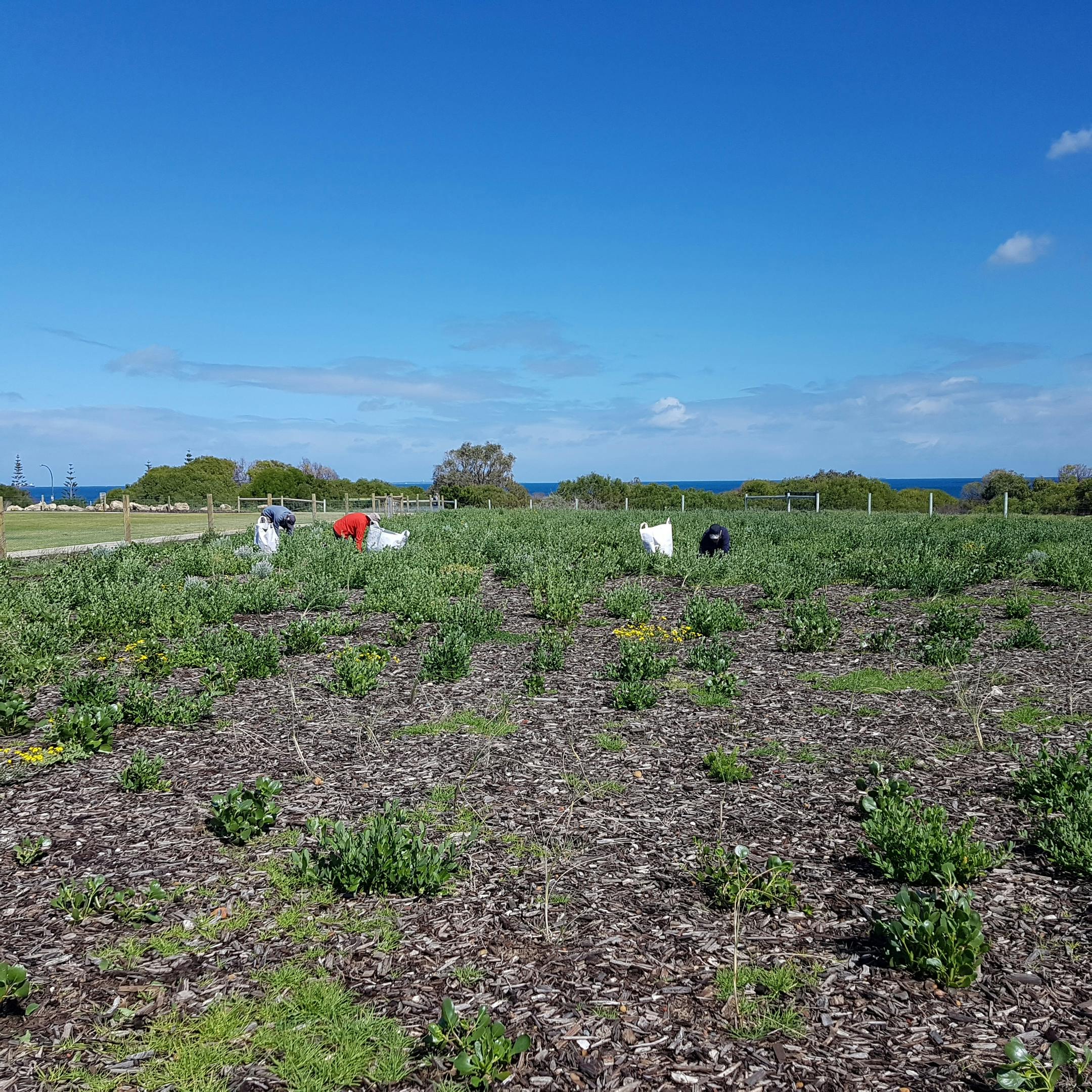
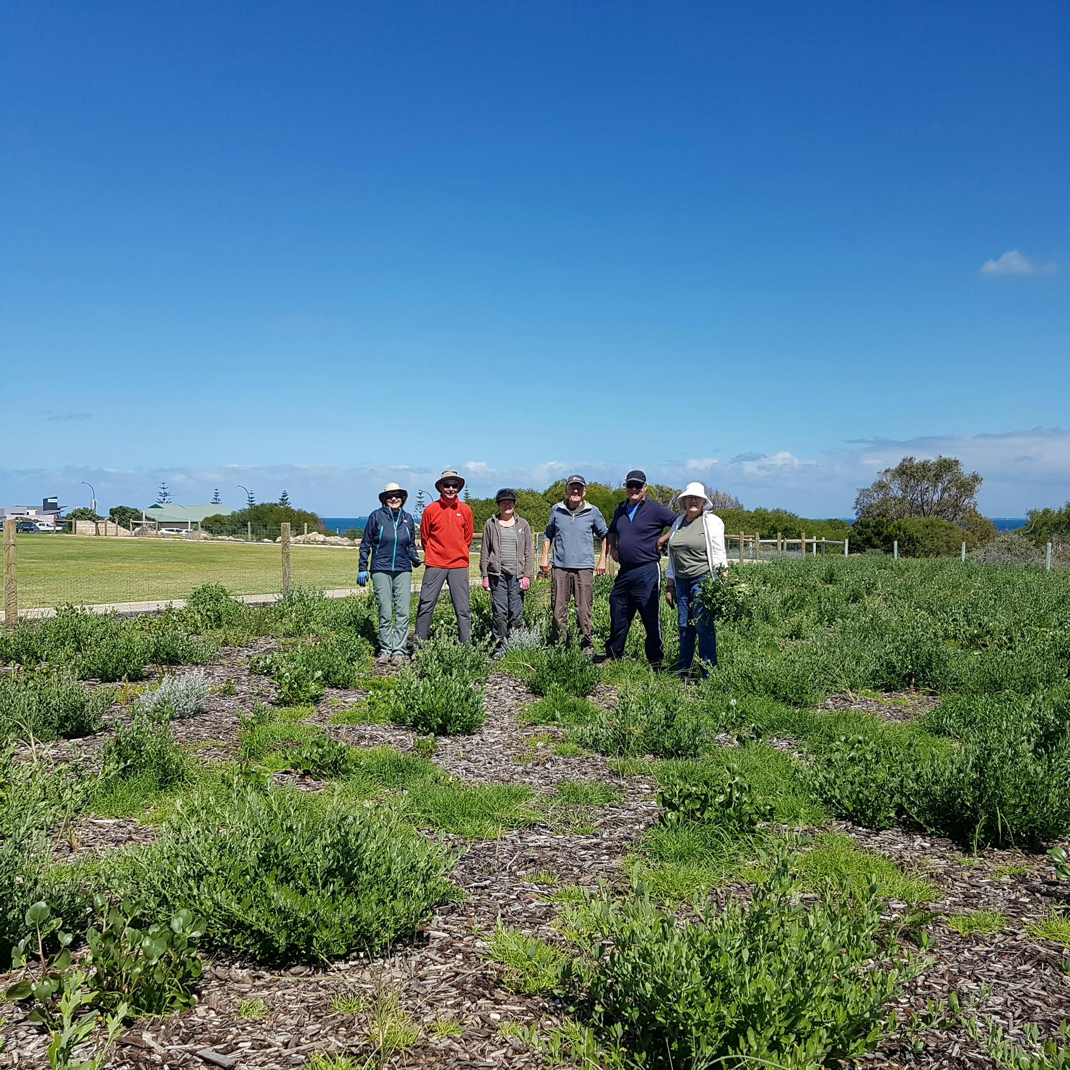
Swanbourne Oval Greenway Development - Stage 1
Share Swanbourne Oval Greenway Development - Stage 1 on Facebook Share Swanbourne Oval Greenway Development - Stage 1 on Twitter Share Swanbourne Oval Greenway Development - Stage 1 on Linkedin Email Swanbourne Oval Greenway Development - Stage 1 linkThe City in conjunction with the Swanbourne Coastal Alliance and the Friends of Allen Park received a grant from the Western Australian Planning Commission through the Coastwest Grants Program 2019/20 to undertake Swanbourne Oval Greenway Development – Stage 1.
This project is being undertaken in accordance with the Allen Park Masterplan and Swanbourne Oval refurbishment works. The project will covert the northern part of Swanbourne Beach Oval to coastal bushland (approximately 2.4 Ha) as well as undertake ongoing restoration of adjacent coastal areas within Allen Park. It will involve site preparation in April/May, followed by installation of certified mulch in May and revegetation with 5500 low growing locally occurring native shrubs and ground covers in June and July.
The project will assist with the City’s aims of protecting biodiversity, providing improved habitats, connectivity for local fauna and increasing the City’s capacity to absorb greenhouse gas emissions.
Objectives
- Increase the integrity of the coastal corridor by developing and enhancing ecological linkages to adjacent coastal areas north and south in Cottesloe and Cambridge;
- Enhance the existing greenway corridor at Allen Park by increasing the area of bushland in the Reserve;
- Removal of invasive weeds;
- Revegetation with local provenance native seedlings;
- Maintenance of public access such as beach fencing;
- Improvement of bushland condition;
- Reducing erosion;
- Increasing habitat of fauna such as the resident White-winged and Chestnut Fairy-wrens
- Strengthening two regional greenways - the coastal greenway and the Bold Park to Kings Park Greenway
- Protection of environmental values and biodiversity within the coastal zone;
- Increasing the atheistic quality of the area; and
- Building capacity by involving the community.
Timeline
ACTIVITY
TIMEFRAME
Site Preparation
April – May 2020
Mulching
May 2020
Planting
June/July 2020
Weed Control
Ongoing
You can view the Greenway Map and FAQs about the project in the document library.
Please see the News and Notices Page for all City updates.


Signup Banner